
The first images surfaced like a whisper from the abyss—gritty, luminous, and undeniably otherworldly. Nearly 16,000 feet below the Pacific, a robotic camera swept its lights across a series of terraced ridges and looming pillars, each face banded with mineral stains like the growth rings of an ancient tree. The site wasn’t on any chart, not even as a blip, and that singular absence gave the discovery a peculiar charge.
No one on the control deck spoke for a breath, then someone laughed, the nervous kind that follows a sudden, impossible view. “We knew we had a seafloor gap,” said one of the scientists, “but we didn’t expect a cathedral of stone.”
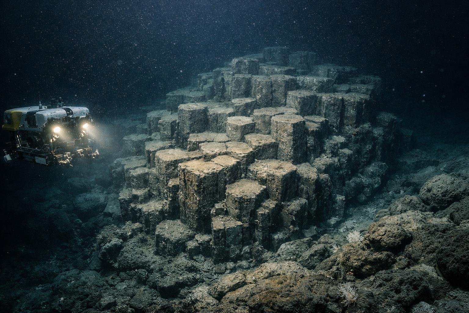
What the cameras revealed
Against the velvet dark, the formation rose in broad, stepped platforms, stacked like an amphitheater carved by a meticulous hand. Surfaces broke into geometric panels, some hexagonal, some oddly fluted, all glazed with a thin skin of black manganese. In side profile, columns lifted like organ pipes, with sills that resembled toppled dominoes.
The ROV’s laser scales measured individual tiers at two to five meters high, with the tallest pillars cresting near 40 meters at their peaks. Interstitial crevices sheltered pale brittle stars and shy, glassy sponges, every movement slow enough to feel like a different time.
Why it wasn’t on the map
The blunt truth is that much of the ocean floor remains unseen, even in our satellite-saturated age. Only about a quarter of the seabed is mapped at high resolution, leaving enormous chasms of simple ignorance. “You can hide a mountain under a kilometer of water,” a navigator joked, “and we’ll still miss it with a guess.”
This patch sat in a quiet zone between active ridges and heavily trafficked routes, the kind of place analysts label “low priority” before moving on to brighter targets. A new autonomous vehicle—long-legged, patient, and exceptionally quiet—stitched a multibeam sonar mosaic that finally popped the formation from background noise.
How a labyrinth of stone might form
Geology loves puzzles, and this one arrived with a pleasingly tangled knot. Three working hypotheses made the early shortlist:
- Off-axis volcanic flows that cooled under pressure, fracturing into jointed columns.
- Carbonate edifices from long-lived cold seeps, later armored in manganese-rich crusts.
- Tectonic uplift along an old fault, then planed by turbidity currents into terraces and ramps.
“Each thread can explain part of the pattern,” said the lead geologist over a soft hum of instruments, “but only samples will decide the story.” A manipulator arm clipped small chips from a pillar’s edge, revealing a fine-grained, basaltic heart under its glossy varnish.
Fragile life in heavy water
There was no blaze of hydrothermal venting, no flamboyant shrimp in scarlet crowds, yet the stone carried a faint fuzz of microbial mats, ash-white and feathery. Amphipods skittered like errant commas, pausing in tight schools when the ROV washed the rock with warmer light.
“It’s a low-energy ecology, but it’s very much alive,” murmured a biologist, eyes fixed on a sponge’s slow pinch. Manganese-encrusted surfaces often host catalyzing microbes, tiny chemists sifting scant nutrients with austere efficiency.
Why it matters beyond wonder
New terrain tightens our models, sharpening forecasts for quakes, tsunamis, and seafloor instabilities. Terraces can redirect turbidity flows, which in turn nudge sediment budgets and long-haul carbon transport. Cable planners, too, eye these features with careful interest, avoiding edges that can shear with surprising speed.
There’s a cultural pull as well. Oceans carry a mythic weight, and every unveiled amphitheater of stone pushes back the rim of the unknown. “Discovery is a public act,” said the expedition lead, “not just a line in a data table.”
Tools that made the invisible visible
The team paired a broad-shouldered sonar sweep with nimble visual transects, blending multibeam bathymetry, side-scan textures, and closeup 4K video. AUVs traced disciplined grids, then the ROV performed stitched walkthroughs of targeted corners, like a cinematographer scouting a set.
Every pass refined a mesh, a living map that evolved on wall-sized screens in the control room. With each iteration, shadows thinned into crisp edges, and guesses hardened into measurable forms.
Guardrails for a new icon
The team’s first instinct wasn’t exploitation but care, complete with slow approach speeds and minimal lighting. They logged noise levels, watched for stress in nearby fauna, and charted no-go radii around vulnerable roofs and ledges.
“Deep places teach patience,” a pilot said, hands hovering over thruster knobs. “If it took geologic time to build, it can’t take a night to know.”
What comes next
Back on deck, cores rest in cool darkness, their ends sealed like precious letters. Thin sections will travel to shore-based labs, where microscopes and microprobes will divide art from mechanism with careful math. Models will be tuned, the formation’s age will be bracketed, and its growth history will be rendered in tidy plots.
There’s talk of a public stream, a cleaned-up traverse from the most dramatic shelf to the tallest column, paired with sonified sonar so viewers can hear the terrain rise and fall. The ocean, patient as ever, won’t mind the attention; the rocks certainly won’t.
In the end, what lingers is scale: a cathedral of basalt, far below storms and shipping, built in silence and held in darkness until a lantern-eyed robot arrived to listen. The map grows by inches and echoes, and somewhere under those terraces a new question is already taking shape.